


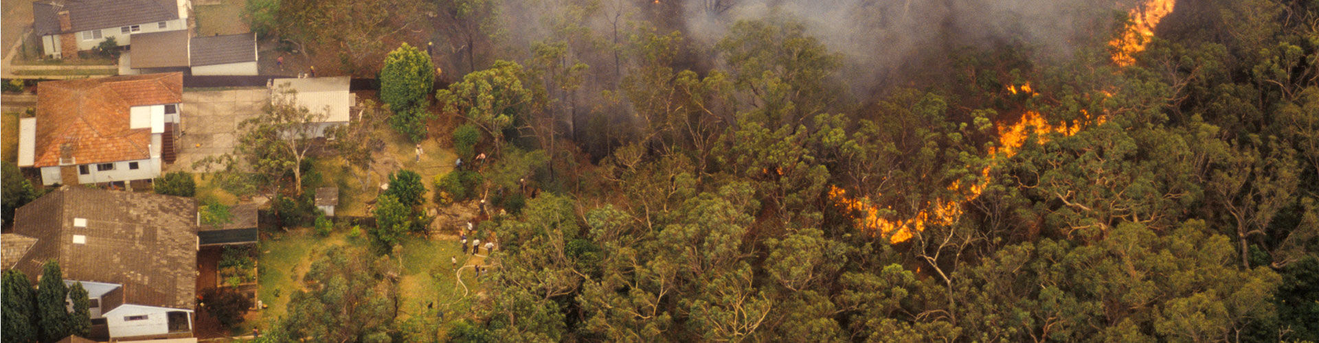
Development on Bush Fire Prone Land
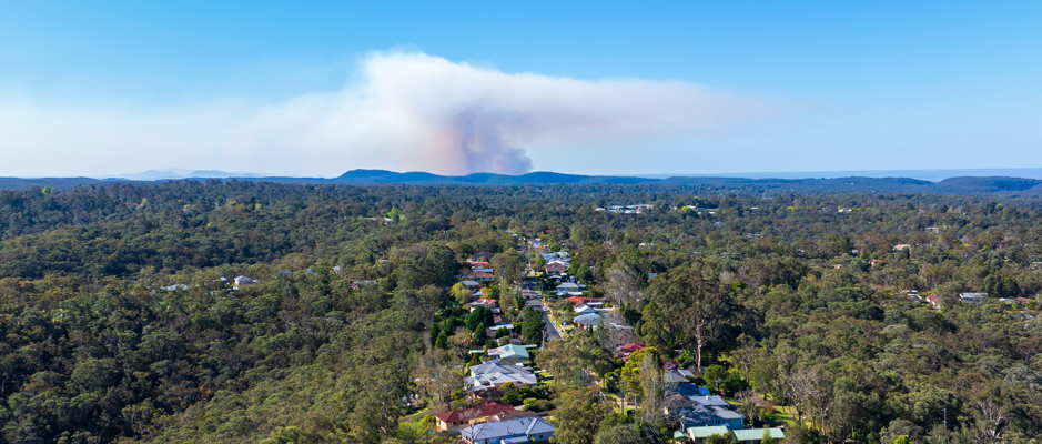
Bush fire prone land (BFPL) is land that has been identified by local council which can support a bush fire or is subject to bush fire attack (including embers, radiant heat and flame). It includes both vegetation and a buffer.
Section 10.3 of the Environmental Planning and Assessment Act 1979 requires councils, where a Bush Fire Risk Management Plan applies, to record a BFPL map.
The Hornsby BFPL map has been prepared by Council and certified by the Commissioner of the NSW Rural Fire Service (RFS).
It is Councils continued commitment to identify land use constraints and impacts on infrastructure when considering strategic proposals and increased housing densities in bush fire prone areas.
Find out if your Property is Bush Fire Prone
The current and applicable Hornsby BFPL Map can be found on both Councils Mapping System and the NSW Rural Fire Service website. A PDF version is also available for download.
Categories within the BFPL Map
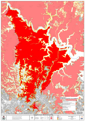
In accordance with the NSW Rural Fire Service Guide for Bush Fire Prone Land Mapping, Hornsby Councils BFPL map displays different vegetation categories:
- Category 1 vegetation (indicated as red) represents the highest risk for bush fire and consists of areas of forest, woodlands, heaths, forested wetlands and timber plantations.
- Category 2 (indicated as light orange) is considered to be a lower bush fire risk and consists of rainforests, remnant vegetation and smaller isolated parcels of land of a shape that prevents significant upslope fire runs.
- Category 3 (indicated as dark orange) is considered to be a medium bush fire risk vegetation and consists of grasslands, freshwater wetlands, semi-arid woodlands, alpine complex and arid shrublands.
- Buffer (indicated as yellow) can be either 100 metres from the vegetation for Category 1 or 30 metres for Category 2 or 3.
The most important thing to understand is that if either the mapped vegetation or the buffer intersects your property, the property is considered to be bush fire prone.
Submission Requirements
In response to devastating losses of life and property in past bush fire events, the NSW Government enacted legislative changes on 1 August 2002 to ensure bush fire matters were considered in the development process. These legislative changes resulted in the creation of Section 4.14 of the Environmental Planning and Assessment Act 1979 and Section 100B of the Rural Fires Act 1997 which require all new development on bush fire prone land to comply with the NSW Rural Fire Service document Planning for Bush Fire Protection.
This document forms the basis for all bush fire planning and bush fire protection measures for new development in NSW. Its intent is to not prevent the development of land in bush fire prone areas but to provide adequate protection from bush fires through the modification of building style, construction material and siting.
For all new development on BFPL, Council requires the following information:
| Development Type | Requirements |
|---|---|
| Exempt Development |
The exempt development standards will advise what materials you can use, usually non-combustible materials or hardwood.
No additional documents are required as exempt development is a self-assessment. |
| Complying Development |
Submit a Bush Fire Attack Level (BAL) Certificate with your Application for a Complying Development Certificate (CDC).
A BAL Certificate verifies the level of bush fire threat in accordance with Planning for Bush Fire Protection. Hornsby Council certifiers can undertake an assessment of the bush fire threat of your property and issue a BAL Certificate in accordance with Section 1.19A of State Environmental Planning Policy (Exempt and Complying Development Codes) 2008. Alternatively, a person who is recognised by the NSW Rural Fire Service as a suitably qualified consultant in bush fire risk assessment can prepare the certificate. To be considered complying development the development must not be carried out on land in bush fire attack level-40 (BAL-40) or the flame zone (BAL-FZ). The fee for a BAL Certificate is listed in Councils Fees and Charges. All BAL Certificate applications must be lodged electronically via Councils Online Services Portal. Documents and plans to be supplied with your BAL Certificate Application include:
|
| Development Application |
In accordance with the Hornsby Development Control Plan (DCP), all development applications on
OR
An Integrated Bush Fire and Vegetation Management Plan (IBVMP) may also be required to inform the removal or modification of vegetation, bushland or habitat for the purposes of establishing an Asset Protection Zone (APZ). A suitably qualified consultant can provide this assessment. Download a copy of the current Guideline. |
Purpose of Bush Fire Protection Measures
Bush fire protection measures in combination, as outlined in Planning for Bush Fire Protection, ensure that development can better withstand the effects of a bush fire event and help ensure risk to existing and future residents, property and community infrastructure is not increased.
In a development assessment context, there are six key bush fire protection measures:
- The provision of clear separation of building and bush fire hazards, in the form of a fuel reduced Asset Protection Zone
- Building construction standards and design
- Appropriate access standards for residents, fire fighters, emergency service workers and those involved in evacuation
- Adequate water supply, pressure and provision of utilities
- Emergency management arrangements for fire protection and/or evacuation
- Suitable landscaping, to limit fire spreading to a building.
Asset Protection Zone (Private land)
An Asset Protection Zone (APZ) is an area surrounding a development that provides sufficient space and is managed to reduce fuel loads to ensure radiant heat levels at buildings are kept below critical limits and prevent direct flame contact. An APZ can consist of both an Inner Protection Area (IPA) and an Outer Protection Area (OPA).
The IPA is designed to minimise direct flame contact and radiant heat and provide residents and emergency service personnel with a defendable space to work within. As a guide the IPA can consist of:
- Trees. Scattered with canopies separated by two to five metres. Canopies should not touch or overhang any buildings. Lower limbs should be removed up to a height of two metres above the ground to prevent fire travelling to the canopy
- Shrubs. Separated or planted and maintained in discontinuous clumps or garden beds away from a building (particularly windows and doors)
- Groundcovers. Kept low (30cm). Grass kept mown (less than 10cm). Fallen leaves, barks, branches, and debris should be raked up and removed from site.
In terms of the built environment within the IPA:
- Any new fences and gates should be constructed of non-combustible material
- Existing and proposed pavements, pathways and driveways should be kept clear of vegetation and debris to provide a defendable space. Avoid storage of flammable or combustible materials/structures within this area.
The OPA is located between the IPA and the unmanaged vegetation and is designed to decrease the intensity of an approaching fire by decreasing the fuel loads. Designation of OPAs assists in areas of steeper slopes, rock terracing, riparian corridors, significant biodiversity value and limited maintenance capabilities. As a guide the OPA can consist of:
- Trees. Canopies should be separated by two metres or maintained in discontinuous clumps
- Shrubs. Separated or maintained in discontinuous clumps
- Groundcovers. Kept low (30cm)
- Significant amounts of fallen bark and branches should be raked away from the base of trees and rock outcrops.
Building and Construction
The application of construction standards that address different levels of heat exposure (also known as Bush Fire Attack Levels (BALs)) can lessen the vulnerability of a structure to ember, radiant heat and flame impact.
BALs are calculated based on regional fire weather, vegetation (fuel loads), effective slope and separation distance to a bush fire hazard.
The construction standards applicable for each BAL are outlined in Australian Standard AS 3959 Construction of buildings in bushfire prone areas and the National Association of Steel-framed Housing Inc NASH Standard for Steel Framed Construction in Bushfire Areas.
Construction requirements apply to floors and exposed subfloors, external walls, glazing, roofs, guttering, gables, eaves and fascias, verandahs and decks and water and gas supplies.
Generally, the higher the BAL, the greater the level of exposure and the more restrictive the requirements on building material.
Access
Design of access roads shall enable safe, all-weather unrestricted access and egress for residents attempting to leave an area while emergency service personnel are arriving to undertake firefighting operations.
The shorter the distance from a development to the public road system the safer the route for evacuating residents and the less impact on the environment.
Access provisions account for roads, driveways and fire trails, prescribing appropriate capacity, carriageway widths, vertical clearances and suitable passing and turnaround areas for firefighting vehicles.
Water and Utilities
Water is essential for firefighting and property protection. Water may come from the mains water supply or from property water supplies (for example, tanks, dams or pools).
Provisions for an additional static water supply are particularly important in rural areas and areas where water pressure from the mains may be compromised. In this instance there may be a requirement to provide a non-combustible Static Water Supply (SWS) tank with storz outlet or access hole, shut off valve, petrol or diesel powered pump and delivery hose.
An approved Static Water Supply sign should be installed at the front of the property, visible to approaching firefighting vehicles, and at other appropriate locations, where required, throughout the site.
Where practicable undergrounding electricity is recommended. Existing overhead lines should be clear of vegetation. Bottled gas installations should be located clear of flammable materials and shielded on the bush fire hazard side with metal connections and venting considerations provided.
Emergency Management
Formal emergency management arrangements are essential for developments that house vulnerable occupants (such as hospitals, retirement villages, nursing homes, schools, preschools and tourist facilities). In these instances, a Bush Fire Emergency Management and Evacuation Plan should be prepared.
For single dwelling developments residents should complete a Bush Fire Survival Plan. A copy of which can be downloaded from the Rural Fire Service website.
Landscaping
Landscaping design should minimise flame contact and radiant heat to buildings and the potential for wind driven embers to cause ignitions. Any new plantings proposed, should be in line with the following landscaping measures:
- Restrict planting in the immediate vicinity of buildings
- When considering landscape species, the size of the plant at maturity and its proximity to the dwelling and other vegetation should be considered
- Avoid canopy species with rough fibrous bark, or which retain/shed bark in long strips or retain dead material in their canopies. Use smooth bark species of trees which generally do not carry a fire up the bark and into the crown
- Avoid planting of deciduous species that may increase fuel at surface/ground level
- Avoid climbing species to walls and pergolas
- Use low flammability shrubs and ground covers. Attributes include large glossy leaves, high moisture content, low level of volatile oils, smooth bark and no accumulation of dead leaves and stem material held within or around the plant
- On the development pathway and requirements within Hornsby Shire Council email hornsbycertifiers@hornsby.nsw.gov.au or phone (02) 9847 6787
- On bush fire protection, assessment and the legal framework that governs the planning process for proposed developments on bush fire prone land visit the NSW Rural Fire Service website.
For more information
On the development pathway and requirements within Hornsby Shire Council email hornsbycertifiers@hornsby.nsw.gov.au or phone (02) 9847 6787.
On bush fire protection, assessment and the legal framework that governs the planning process for proposed developments on bush fire prone land visit the NSW Rural Fire Service website.
Need a Consultant?
There is a list qualified Bush Fire Planning and Design (BPAD) consultants on the Fire Protection Association (FPA) Australia website. Accredited practitioners listed with FPA Australia are recognised by industry, regulators, fire agencies, end-users and the community as providers of professional bush fire assessment, planning, design and advice services. For more information visit FPA Australia.