What is our future direction?

Our Water Sensitive Future

The 50-year vision for Hornsby Shire is to be a beautiful, green, and thriving shire whose management of water and the environment supports clean waterways, sustainable resource use, and a healthy lifestyle that is connected to nature.

The vision encompasses six statements that define the outcomes to be ensured:

  1. Hornsby’s natural environments are healthy and thriving with biodiversity
  2. Hornsby and its villages are full of beautiful blue and green spaces that connect people to their surrounding environment and local community
  3. Hornsby Shire has engaged, empowered and active communities who value Aboriginal and multi-cultural connections to land and water
  4. A strong focus on water management supports safe communities and healthy, clean rivers and creeks
  5. Sustainable resource use is supported by integrated, multi-functional infrastructure
  6. Integrated and inclusive governance arrangements deliver a holistic approach to water management while meeting the challenges of growth

The Vision and Transition Strategy for a Water Sensitive Hornsby defines a vision of a water sensitive future for Hornsby Shire and outlines the broad steps Hornsby Shire should take to enable a transition towards its future. It is the outcome of ten months of research, analysis and engagement with 24 community champions and 34 leading thinkers from across water, planning, development and environment sections in Hornsby Shire Council.

Water sensitive Hornsby

This Water Sensitive Hornsby Strategy defines a vision of a water sensitive future for Hornsby Shire, and outlines the broad steps for Council to take to transition towards this future. The project developed and applied methods and tools of the Cooperative Research Centre for Water Sensitive Cities (CRCWSC) designed to consider a city’s long-term water aspirations, benchmark current water sensitive performance and explore strategic priorities for the short- to medium-term that will be important in pursuing its water sensitive city vision. These approaches have helped situate Hornsby Shire on its water sensitive city transition journey and identified the critical interventions to enable progress.

Since the early 1990s, Council has led the way in the implementation of water sensitive urban design, largely through the Catchments Remediation Rate program. Despite this proactive approach, challenges still exist, such as changing government priorities, impacts from existing and future development and increasing pressure on water systems from climate change. Council needs to plan wisely to adequately service a growing population in a warming and drying climate, while ensuring sustainable, environmental, and liveability outcomes for the region.

The purpose of this Strategy is to provide a framework for orienting and coordinating strategic action across the many different stakeholders who will need to collaborate for Hornsby Shire’s envisioned water future to be achieved. The Strategy provides a snapshot of Hornsby Shire’s performance and transition progress at this point in time and in relation to moving forward identifies actions designed to progress Hornsby Shire’s transition towards a water sensitive city.

The Water Sensitive Hornsby Strategy, adopted by Council in March 2021, fits under the Environmental Sustainability Strategy – Sustainable Hornsby 2040 and is part of the Sustainability theme of the Community Strategic Plan 2018-2028.

Coastal and estuary planning

Waterways are a huge part of the Hornsby Shire community’s lifestyle. They underpin our identity, support our local economy, provide recreational and social opportunities for locals and visitors, and support our mental and physical wellbeing.

A great deal of planning and research has been undertaken within the Hawkesbury River system throughout the years. Up to now, the River has often been managed in a segmented approach to address locally specific issues or through estuary management and other plans across smaller sections of river and catchments that align with local council areas. Estuary Management Plans were developed for Berowra and Brooklyn area which then were combined into the Lower Hawkesbury Estuary Management Plan in 2008 (Wisemans Ferry to Junio Point). This plan included strategies in the following themes:

  • Planning – ensuring planning instruments include best practice and provisions for sustainable development
  • Research – undertaking programs to monitor estuarine health and prepare for climate change
  • Education – engaging local communities and schools through estuary awareness activities
  • Compliance – encouraging riverside settlements to implement sustainable practices
  • On-ground works – installing infrastructure and undertaking regeneration programs to protect estuarine assets.

Currently Hornsby Shire Council is working on two key projects aim to protect and improve estuary and catchment planning through development of Coastal Management Programs (CMPs) for the Hawkesbury-Nepean River and Sydney Harbour. Both projects are supported by the NSW Government’s Coastal and Estuary Grant Program.

Under the Coastal Management Act 2016 No 20 - NSW Legislation (CM Act) councils may prepare CMPs which set out the long-term strategy for the coordinated management of the coast, with a focus on achieving the objects and objectives of the CM Act. The CMPs will be developed and guided by the NSW State Government's Coastal Management Manual.

CMPs identify management issues in the coastal area, the actions required to address these issues, and how and when those actions will be implemented. They detail costs and proposed cost-sharing arrangements and other viable funding mechanisms.

Hawkesbury-Nepean CMP

Hornsby Shire Council is leading a partnership with the other five Councils that have management responsibility of land and coastline along the river, to prepare a Coastal Management Program (CMP) for the Hawkesbury-Nepean River System. The project covers the area of estuary between Yarramundi (the tidal limit of the river) to the estuary entrance between Box Head and Barrenjoey Head and includes Brisbane Water, Broken Bay and Pittwater.

Our partnering councils are: Hawkesbury City Council, The Hills Shire Council, Central Coast Council, Ku-ring-gai Council and Northern Beaches Council. Having the six Councils working together on this project means we can use an integrated approach to manage the Hawkesbury estuary/river on issues that cross jurisdictional boundaries.

The CMP will set out the long-term strategy for the coordinated management of the coastal zone along the Hawkesbury including its creeks, lagoons, littoral rainforests, wetlands, beaches and associated catchments. The program will focus on achieving coastal management objectives at a local level whilst, also achieving the objectives of the NSW Coastal Management framework.

The CMP will provide:

  • an opportunity for councils, public authorities and local communities to identify and balance competing interests and priorities in the coastal zone
  • implement NSW government guidelines for coastal management
  • provide recommendations for the future management of the Hawkesbury-Nepean River system
  • The CMP will guide how issues will be dealt with, who is responsible, where funding will come from and when actions will be undertaken.

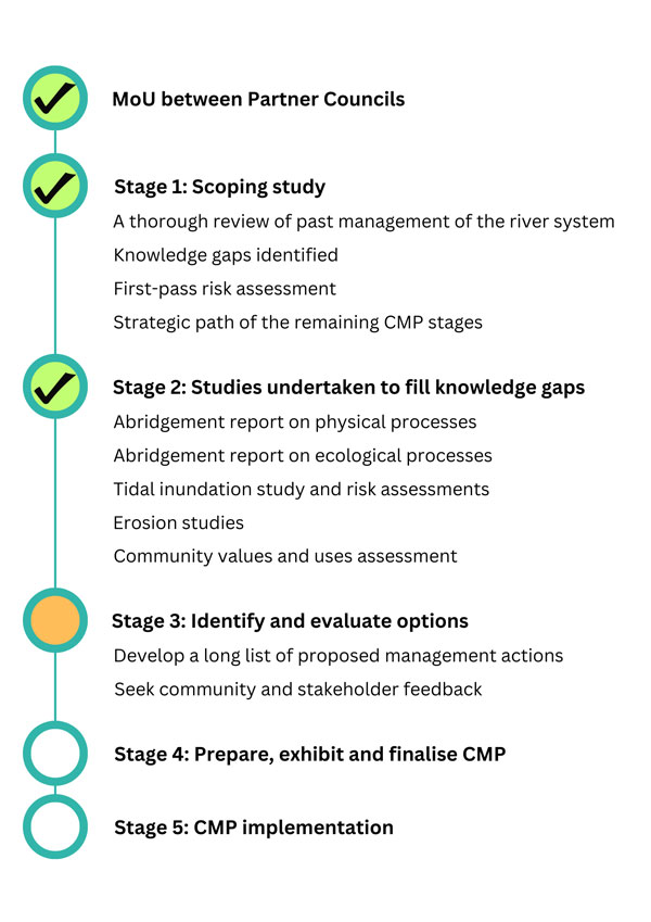
In March 2024, the project received additional funding to deliver Stages 3-4 of the CMP. To view the latest information about the CMP progress and all the planned stakeholder and community engagement activities, please visit our CMP website. You can also be kept informed about the CMP by registering your interest.


Useful links

Sydney Harbour CMP

Twenty councils within the Greater Sydney Harbour catchment are collaborating with state agencies to develop a whole-of-system approach through a Greater Sydney Harbour Coastal Management Program (GSHCMP). The Sydney Coastal Councils Group (SCCG) is project managing the delivery of this CMP.

Stage 1 Scoping Study has identified urban stormwater discharge as a high priority threat to environmental and public health.

Sydney Harbour Water Quality Improvement Plan has also been completed and provides a strong base for the development of the GSHCMP.

To assess threats posed by pollutants being carried into Sydney Harbour waters, a Stage 2 investigation will determine risks across all catchments feeding the Harbour and steps needed to mitigate those risks. The aim is to provide support for coordinated action by councils, in partnership with state agencies and the community, to facilitate integrated waterway health management for the entire Greater Sydney Harbour system. This Stage 2 investigation will bring together available information on urban stormwater and apply existing tools (such as the Risk Based Framework) in a coordinated way. It will also enable individual councils to work with State Agencies to develop projects/actions for consideration in Stage 3. The investigation will also involve community and stakeholder engagement.


Useful links

Water conservation

Water conservation has become an increasingly important issue over the last few years. Further expansion of development within Hornsby Shire will place pressure on our water supply and will require all residents, as well as Council, to reduce water use.

Hornsby Shire is home to 151,811 people (2021 Census). This is expected to grow to 174,884 by 2036. This equates to at least 14,343 new residential dwellings within the existing residential areas of Hornsby, Asquith and Waitara.

Hornsby has amongst the highest water consumption per dwelling for LGAs in the Greater Sydney region with external water used in gardens and pools a significant influence on water use. Currently the combined water required for all residents, businesses and council services in Hornsby Shire is 14.4 billion litres of drinking water a year. The expected population growth will result in the consumption of an extra 2 billion litres of water a year to meet residential, industrial and commercial demands.

The growth in population, dwellings and infrastructure will increase:

  • Demand for drinking water
  • Stormwater runoff flowing off roads and buildings and into our creeks
  • The need for water sensitive urban design (WSUD) assets that reduce flooding and minimise pollutant loads to the Shire's waterways

How can you be more water efficient?

With the rising cost of living there are easy ways to save water and money. Discover ways to make your home more sustainable and cut your water (and energy) usage:

Water legislation

Managing New South Wales water resources relies on a range of legislation, initiatives and cooperative arrangements with the Commonwealth and other state governments. The key piece of legislation for the management of water in NSW is the Water Management Act 2000 (WM Act).

The object of the Water Management Act 2000 is the sustainable and integrated management of the state's water for the benefit of both present and future generations.

The Water Management Act 2000 is based on the concept of ecologically sustainable development – development today that will not threaten the ability of future generations to meet their needs. The Act recognises:

  • the fundamental health of our rivers and groundwater systems and associated wetlands, floodplains, estuaries have to be protected
  • the management of water must be integrated with other natural resources such as vegetation, soils, and land
  • to be properly effective, water management must be a shared responsibility between the government and the community
  • water management decisions must involve consideration of environmental, social, economic, cultural and heritage aspects
  • social and economic benefits to the state will result from the sustainable and efficient use of water.

Whereas the WM Act provides for the integrated and sustainable management of the State’s waters, the Protection of the Environment Operations Act 1997 (POEO Act) provides the statutory framework for managing water pollution in NSW. There is a broad allocation of responsibilities under the POEO Act between the EPA, local councils, and other public authorities.

Find out further information about who investigates water pollution

Catchment prioritisation

The Hornsby LGA lies within the broader Hawkesbury-Nepean catchment and partially the Sydney Harbour catchment, encompassing more than 1320km of creeks and rivers. The 4 major catchment areas in the Hornsby LGA are Berowra Creek, Cowan Creek, (upper) Lane Cove River and the Hawkesbury River. These catchments can be further categorised into 14 major stormwater sub-catchments and 55 smaller sub-catchments.

Waterway health ranges from pristine creeks, contained within National Parks, to highly modified and degraded systems downstream of urban and industrial areas. Council has limited funding available to protect and enhance waterway condition, so it is crucial this money is used most effectively. To ensure funding is targeted appropriately, Council has identified high priority sub-catchments where management actions could assist with the protection of higher value waterways from risks.

A preliminary risk assessment was completed for each sub-catchment based on an approach outlined by the State Government in the Risk-based framework for considering waterway health outcomes in strategic land use planning decisions. Each of the 55 minor sub-catchments were subsequently assigned a priority of low, medium, high or very high priority.

As a result of this study, Council has selected the headwaters of Berowra Creek in the south-western corner of the Shire as the priority catchment for further work and will be heavily focusing future catchment management activities in this area.

NSW Department of Planning and Environment have also developed a two page RbF case study using Hornsby Shire as an example of how existing data collected by Councils can be retrofit to apply the Risk-based Framework in a cost-effective way.