


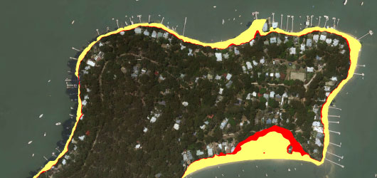
Sea Level Rise Map
What are the predicted sea level rises?
It is predicted the mean sea level will rise 0.4 metres above the 1990 level by 2050. By 2100 it is predicted the level will rise by 0.9 metres above the 1990 level.
How do I know if my land is affected?
The CSIRO, on behalf of the Sydney Coastal Council Group (SCCG), has undertaken modelling of coastal inundation under future sea levels. They have released Sea Level Rise Maps - 3.2MB for Hornsby Shire that will help residents understand the impact of predicted sea levels.
A Section 149(2) and (5) Planning Certificate issued by Council will confirm whether land is exposed to the risk of future tidal inundation.
What are the implications for development?
There are restrictions on development on land that is affected by tidal inundation, which are designed to minimise the risk to property and the environment in the event of a “once in 100 year” flood. These include:
- Siting the level of habitable rooms, wet areas and other sensitive uses (such as on-site wastewater disposal areas) above the predicted 2100 sea level rise of 0.9 metres;
- Siting non-habitable structures (such as sheds, decks and pergolas) above the predicted 2050 sea level rise of 0.4 metres.
Modelling and Mapping of Coastal Inundation under Future Sea Level Report - 2.5MB